照片to谷歌地球/奥维地图新增功能 导出 GeoJSON 数据

在地理信息处理领域,数据格式的选择对于数据的存储、传输和可视化至关重要。近期,照片to谷歌地球软件/奥维地图在更新到1.2.1版本时,在原有可以把gps数据导出成excel文件的基础之上,新增了导出 GeoJSON 数据的功能,这让用户能够更灵活地处理和展示照片中的 GPS 信息。下面,我们先来了解一下 GeoJSON 和 Points 这两个重要概念。

什么是 GeoJSON?

GeoJSON 是一种基于 JSON(JavaScript Object Notation)的开放标准格式,用于表示地理空间信息数据。它轻量、易读,并且被广泛支持,许多地理信息系统(GIS)软件、地图库和在线地图服务都支持 GeoJSON 格式。GeoJSON 可以表示点、线、多边形等多种地理空间对象,同时还能为这些对象添加属性信息。

GeoJSON 的优势在于:

  1. 跨平台兼容:几乎所有的 GIS 软件和地图库都支持 GeoJSON 格式。
  2. 易于阅读和编辑:基于文本的格式,人类和机器都能轻松理解。
  3. 支持属性数据:可以为地理空间对象添加额外的描述信息。

什么是 Points?

在 GeoJSON 中,Points(点)是最基本的几何对象之一,用于表示地理空间中的一个特定位置。每个点由一对经纬度坐标组成,在 GeoJSON 中,点的表示格式如下:

1
2
3
4
5
6
7
8
9
10
{
"type": "Feature",
"geometry": {
"type": "Point",
"coordinates": [经度, 纬度]
},
"properties": {
"name": "地点名称"
}
}

照片to谷歌地球/奥维地图如何导出 GeoJSON Points?

照片to谷歌地球/奥维地图软件一直致力于帮助用户将照片中的 GPS 信息可视化到地图上。现在,新增的导出 GeoJSON 功能让用户能够将这些 GPS 信息保存为标准的 GeoJSON 文件,方便在其他地理信息系统中进一步分析和处理。

功能原理

当用户将带有 GPS 信息的照片导入到软件中时,软件会自动识别照片中的 GPS 数据,提取出经纬度信息。然后,软件会将这些经纬度信息转换为 GeoJSON 格式的 Points 对象,并为每个点添加相应的属性信息,如照片文件名、拍摄时间等。

使用步骤

  1. 上传照片:将带有 GPS 信息的照片拖拽到软件指定区域。
  2. 设置参数:根据需要选择地图类型和图标样式。
  3. 导出数据:点击导出成geojson数据旁边的按钮,即可保存包含所有照片 GPS 信息的 GeoJSON 文件。

示例输出

以下是一个由照片to谷歌地球导出的 GeoJSON 文件示例:

1
2
3
4
5
6
7
8
9
10
11
12
13
14
15
16
17
18
19
20
21
22
23
24
25
{
"type": "FeatureCollection",
"features": [
{
"type": "Feature",
"geometry": {
"type": "Point",
"coordinates": [116.404, 39.915]
},
"properties": {
"filename": "IMG_0001.jpg"
}
},
{
"type": "Feature",
"geometry": {
"type": "Point",
"coordinates": [116.414, 39.925]
},
"properties": {
"filename": "IMG_0002.jpg"
}
}
]
}

总结

照片to谷歌地球新增的导出 GeoJSON 功能,为用户提供了一种更灵活、更标准的方式来处理和分享照片中的 GPS 信息。无论是进行地理空间分析,还是在其他地图应用中展示数据,GeoJSON 格式都能满足你的需求。赶快试试这个新功能,挖掘照片中隐藏的地理信息吧!

免费MCP服务:Excel CSV 转 JSON MCP by WTSolutions 文档

简介

Excel 转 JSON MCP(模型上下文协议)提供了一个标准化接口,用于通过模型上下文协议将 Excel 和 CSV 数据转换为 JSON 格式。此 MCP 实现提供了两个专门用于数据转换的工具:

  • excel_to_json_mcp_from_data:转换制表符分隔或逗号分隔的文本数据
  • excel_to_json_mcp_from_url:从提供的 URL 转换 Excel 数据

服务器配置

1
2
3
4
5
6
7
8
9
10
11
12
13
14
15
{
"mcpServers": {
"excel_to_json_by_WTSolutions": {
"args": [
"mcp-remote",
"https://mcp.wtsolutions.cn/sse"
],
"command": "npx",
"tools": [
"excel_to_json_mcp_from_data",
"excel_to_json_mcp_from_url"
]
}
}
}

MCP 工具

excel_to_json_mcp_from_data

将制表符分隔或逗号分隔的文本数据转换为 JSON 格式。

参数

参数 类型 是否必需 描述
data 字符串 制表符分隔或逗号分隔的文本数据,至少包含两行(标题行 + 数据行)

示例请求

1
2
3
4
5
6
{
"tool": "excel_to_json_mcp_from_data",
"parameters": {
"data": "Name\tAge\tIsStudent\nJohn Doe\t25\tfalse\nJane Smith\t30\ttrue"
}
}

excel_to_json_mcp_from_url

从提供的 URL 转换 Excel 或 CSV 文件为 JSON 格式。

参数

参数 类型 是否必需 描述
url 字符串 指向 Excel(.xlsx)或 CSV 文件的 URL

示例请求

1
2
3
4
5
6
{
"tool": "excel_to_json_mcp_from_url",
"parameters": {
"url": "https://example.com/path/to/your/file.xlsx"
}
}

响应格式

MCP 工具返回具有以下结构的 JSON 对象:

字段 类型 描述
isError 布尔值 指示处理请求时是否发生错误
msg 字符串 “success”(成功)或错误描述
data 字符串 使用 URL 时,为工作表对象数组形式的转换后数据;使用直接数据时,为字符串形式;发生错误时为空字符串。使用 URL 时,每个工作表对象包含“sheetName”(字符串)和“data”(对象数组)

示例成功响应

1
2
3
4
5
6
{
"content": [{
"type": "text",
"text": "{\"isError\":false,\"msg\":\"success\",\"data\":\"[{\"Name\":\"John Doe\",\"Age\":25,\"IsStudent\":false},{\"Name\":\"Jane Smith\",\"Age\":30,\"IsStudent\":true}]\"}"
}]
}

数据类型处理

API 会自动检测并转换不同的数据类型:

  • 数字:转换为数值类型
  • 布尔值:识别“true”/“false”(不区分大小写)并转换为布尔值
  • 日期:检测各种日期格式并进行适当转换
  • 字符串:视为字符串值
  • 空值:表示为空字符串

对数据和 URL 的要求

excel_to_json_mcp_from_data

  • 输入数据必须是制表符分隔或逗号分隔的文本,至少包含两行(标题行 + 数据行)。
    1. 第一行将被视为“标题”行,本 API 会将其用作列名,进而作为 JSON 键。
    2. 后续行将被视为“数据”行,本 API 会将其用作 JSON 值。

excel_to_json_mcp_from_url

  • Excel 文件的每个工作表应至少包含两行(标题行 + 数据行)。
    1. 第一行将被视为“标题”行,本 API 会将其用作列名,进而作为 JSON 键。
    2. 后续行将被视为“数据”行,本 API 会将其用作 JSON 值。
  • 此 Excel 文件应为“.xlsx”格式。
  • Excel 文件的每个工作表将被转换为一个 JSON 对象。
  • 每个 JSON 对象将具有“sheetName”(字符串)和“data”(对象数组)属性。
  • “data”数组中的每个 JSON 对象将具有与列名对应的属性。
  • “data”数组中的每个 JSON 对象将具有与单元格值对应的数值。

错误处理

API 针对常见问题返回描述性错误消息:

  • Excel Data Format Invalid:当输入数据不是制表符分隔或逗号分隔时
  • At least 2 rows are required:当输入数据少于 2 行时
  • Both data and url received:当同时提供“data”和“url”参数时
  • Network Error when fetching file:从提供的 URL 下载文件时出错
  • File not found:在提供的 URL 处找不到文件时
  • Blank/Null/Empty cells in the first row not allowed:当标题行包含空单元格时
  • Server Internal Error:发生意外错误时

定价

目前免费。

捐赠

https://buymeacoffee.com/wtsolutions

Image Pixel RGBA Extractor:免费在线图像像素色彩提取工具全解析

引言

在数字设计、图像分析和开发过程中,精准获取图像中每个像素的色彩信息往往至关重要。今天为大家推荐一款功能强大且完全免费的在线工具——Image Pixel RGBA Extractor,它能帮助您轻松提取图像中所有像素的RGBA值,支持多种输出格式,无需安装任何软件,直接在浏览器中完成所有操作。

工具网站

https://s.wtsolutions.cn/image-pixel-rgba.html

工具简介

Image Pixel RGBA Extractor是由WTSolutions开发的一款专业图像色彩分析工具,具备以下核心特性:

  • 支持多种图像格式:PNG、JPG、JPEG、GIF、WebP
  • 三种输出格式选择:RGBA()格式、十六进制格式、逗号分隔格式
  • 本地处理机制:所有图像均在您的浏览器中处理,不会上传至服务器
  • 简洁直观的用户界面,适合各类用户使用

使用指南

使用Image Pixel RGBA Extractor只需简单三步:

第一步:上传图像

您有两种上传方式可选:

  • 拖放上传:直接将图像文件拖拽到页面中央的虚线框内
  • 文件选择:点击”Choose Files”按钮,从本地文件系统中选择图像

第二步:选择输出格式

在上传区域下方的下拉菜单中,选择您需要的输出格式:

  • RGBA()格式:如RGBA(255,255,255,255)
  • 十六进制格式:如#FF0000FF
  • 逗号分隔格式:如255,0,0,255

第三步:获取结果

处理完成后,包含所有像素色彩值的CSV文件将自动下载到您的设备。您可以用Excel、Google表格或任何文本编辑器打开查看结果。

视频演示

[video(video-PocrrLfQ-1751602592637)(type-bilibili)(url-https://player.bilibili.com/player.html?aid=114356809375645)(image-https://i-blog.csdnimg.cn/img_convert/948186f3cb307ed7099e09bfece1be93.jpeg)(title-提取图片每个像素的rgba 值视频演示)]

应用场景

Image Pixel RGBA Extractor适用于多种专业场景:

网页与UI设计

设计师可以快速提取参考图像的色彩方案,确保设计作品的色彩一致性。通过分析优秀设计的像素色彩分布,还能获得灵感启发。

数据可视化

科研人员和数据分析师可利用工具提取图表、热图中的色彩数据,将视觉信息转化为可量化的数值数据,便于进一步分析和处理。

游戏开发

游戏开发者能够精确获取素材图像中的色彩值,用于游戏场景构建、角色设计和特效制作,确保视觉效果的一致性。

数字艺术创作

数字艺术家可以分析经典作品的色彩构成,学习色彩运用技巧,或将提取的色彩方案应用到自己的创作中。

印刷与出版

印刷行业专业人员可准确获取图像色彩数据,确保印刷品与数字设计的色彩一致性,减少色差问题。

相比类似软件的优势

Image Pixel RGBA Extractor在众多同类工具中脱颖而出,主要优势体现在:

1. 完全本地处理,保障隐私安全

与许多在线工具不同,本工具所有处理均在本地浏览器中完成,您的图像文件不会上传到任何服务器,确保敏感图像数据的安全性。

2. 无需安装,即开即用

作为纯网页应用,无需下载安装任何软件,节省设备空间,兼容各种操作系统,只要有浏览器就能使用。

3. 多种输出格式,满足不同需求

提供三种常用色彩格式输出,满足设计、开发、科研等不同场景的需求,无需额外转换格式。

4. 简洁高效的用户体验

直观的界面设计让操作变得简单,即使是非专业用户也能快速上手,处理过程自动化,节省时间和精力。

5. 支持多种图像格式

广泛支持主流图像格式,无需预先转换图像格式,提高工作效率。

开始使用

立即访问Image Pixel RGBA Extractor开始体验(请替换为实际网址)。如有任何问题或建议,欢迎通过用户反馈表单与我们联系。

结语

Image Pixel RGBA Extractor凭借其便捷性、安全性和专业性,成为图像色彩提取领域的理想选择。无论您是设计师、开发者、科研人员还是数字艺术爱好者,这款工具都能为您的工作流程带来显著提升。现在就尝试使用,开启精准色彩提取之旅吧!

Image Pixel RGBA Extractor: Comprehensive Guide to Free Online Image Pixel Color Extraction Tool

Introduction

In digital design, image analysis, and development processes, accurately obtaining color information for each pixel in an image is often crucial. Today, we recommend a powerful and completely free online tool - Image Pixel RGBA Extractor, which helps you easily extract RGBA values for all pixels in an image, supporting multiple output formats, no software installation required, and all operations completed directly in your browser.

Tool Overview

Image Pixel RGBA Extractor is a professional image color analysis tool developed by WTSolutions, featuring the following core characteristics:

  • Supports multiple image formats: PNG, JPG, JPEG, GIF, WebP
  • Three output format options: RGBA() format, hexadecimal format, comma-separated format
  • Local processing mechanism: All images are processed in your browser without being uploaded to servers
  • Clean and intuitive user interface suitable for all types of users

Access the tool

https://s.wtsolutions.cn/image-pixel-rgba

User Guide

Using Image Pixel RGBA Extractor requires just three simple steps:

Step 1: Upload Image

You have two upload options:

  • Drag and drop upload: Directly drag image files into the dashed box in the center of the page
  • File selection: Click the “Choose Files” button to select images from your local file system

Step 2: Select Output Format

In the dropdown menu below the upload area, select your desired output format:

  • RGBA() format: e.g., RGBA(255,255,255,255)
  • Hexadecimal format: e.g., #FF0000FF
  • Comma-separated format: e.g., 255,0,0,255

Step 3: Get Results

After processing is complete, a CSV file containing all pixel color values will be automatically downloaded to your device. You can open and view the results with Excel, Google Sheets, or any text editor.

Video Guide

[video(video-N8D8umUQ-1751602800581)(type-bilibili)(url-https://player.bilibili.com/player.html?aid=114543942440788)(image-https://i-blog.csdnimg.cn/img_convert/9faf831cad34b3b29530de49e2a63787.jpeg)(title-Extracting rgba color values from images using web tool Image Pixel RGBA Extract)]

Application Scenarios

Image Pixel RGBA Extractor is suitable for various professional scenarios:

Web and UI Design

Designers can quickly extract color schemes from reference images to ensure color consistency in design work. By analyzing pixel color distribution in excellent designs, you can also gain inspirational insights.

Data Visualization

Researchers and data analysts can use the tool to extract color data from charts and heatmaps, converting visual information into quantifiable numerical data for further analysis and processing.

Game Development

Game developers can accurately obtain color values from material images for game scene construction, character design, and special effects production, ensuring consistency in visual effects.

Digital Art Creation

Digital artists can analyze the color composition of classic works, learn color application techniques, or apply extracted color schemes to their own creations.

Printing and Publishing

Printing professionals can accurately obtain image color data to ensure color consistency between printed materials and digital designs, reducing color difference issues.

Advantages Over Similar Software

Image Pixel RGBA Extractor stands out among many similar tools with the following key advantages:

1. Fully Local Processing for Privacy Security

Unlike many online tools, all processing occurs locally in your browser. Your image files are never uploaded to any server, ensuring the security of sensitive image data.

2. No Installation Required, Ready to Use

As a pure web application, there’s no need to download or install any software, saving device space and compatible with various operating systems - just a browser is needed.

3. Multiple Output Formats for Different Needs

Three commonly used color formats are provided to meet the needs of different scenarios such as design, development, and scientific research, eliminating the need for additional format conversion.

4. Clean and Efficient User Experience

The intuitive interface design makes operation simple, even for non-professional users to get started quickly. The automated processing saves time and effort.

5. Support for Multiple Image Formats

Widely supports mainstream image formats without the need for pre-conversion, improving work efficiency.

Get Started

Visit Image Pixel RGBA Extractor now to start your experience (please replace with actual URL). If you have any questions or suggestions, feel free to contact us through the user feedback form.

Conclusion

With its convenience, security, and professionalism, Image Pixel RGBA Extractor has become an ideal choice in the field of image color extraction. Whether you’re a designer, developer, researcher, or digital art enthusiast, this tool can significantly enhance your workflow. Try it now and start your precise color extraction journey!
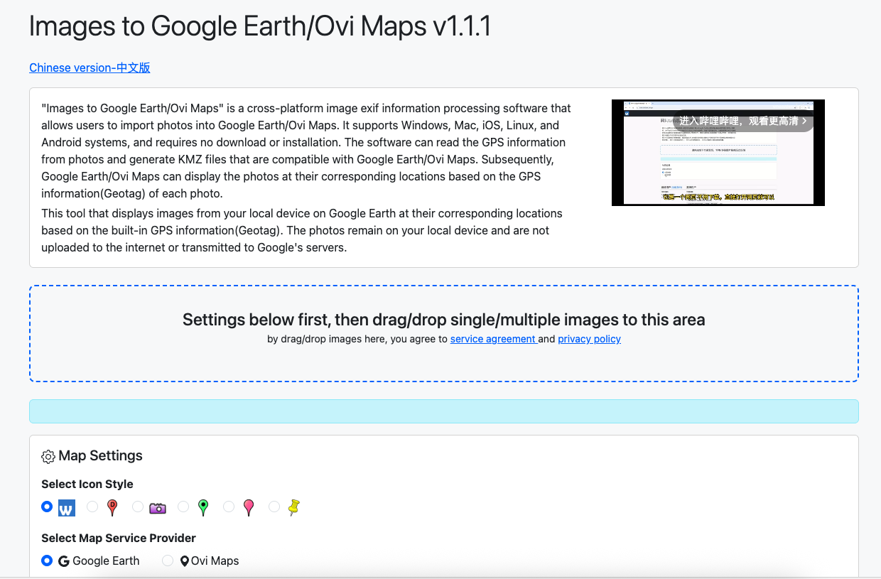
Images to Google Earth/Ovi Maps - How to view local photos on Google Earth?

Questions to be solved?

  • How to view local photos on Google Earth?
  • How to display local images as geotagged placemarks on Google Earth?
  • How to put geotagged pictures on Google Earth?
  • How to view local images from Google Earth at the place where images were taken?
  • Displaying geotagged photos on Google Earth?
  • How to convert geotagged pictures to KMZ/KML files?
  • How to show local images as overlays on Google Earth?
  • KMZ file show images as place marks?
  • Images embedded in kms files show up in Google Earth?
  • Converting Geotagged photos to KML photo overlays on Google Earth?
  • Have geotagging photos displayed on Maps?
  • Creating place marks from geotagged photos?

Solutions

If you have one of the above questions, you can use the Images to Google Earth/Ovi Maps tool to solve it at https://s.wtsolutions.cn/gpsen.html

Sanpshot

images-to-google-earth-ovi-maps

Images to Google Earth/Ovi Maps

Images to Google Earth/Ovi Maps is a tool that allows you to display local geotagged images on Google Earth as one place mark overlay at corresponding GPS locations. All images stays on your local device, and will not be uploaded to Google Earth server, therefore only you and those who have your kmz files can view them.

How it works

  • Users Drag one photo or serveral photos to the dotted area on the website;
  • This tool will analyse the EXIF data of the photo and extract the GPS information;
  • This tool write the GPS information to the KMZ file, within the KMZ file, all images will be instructed to be displayed as one place mark overlay at corresponding GPS locations;
  • Users download KMZ file, and open it with Google Earth or Ovi Maps (Kmz file and images are all in the same folder on your local device);
  • From Google Earth/Ovi Maps, users can view all images as one place mark overlay at corresponding GPS locations;
  • Users click on one of the place mark icons, a overlay window will be displayed, and the image will be displayed in the overlay window;
  • In the window, users can view Filename, Latitude, Longitude, Altitude, and the photo displayed;

Extracting GPS data and export to CSV file

  • After users drag photos to the dotted area, they can click the “Export to CSV File” button in the “Pro Users” area;
  • This tool will extract the GPS information from the EXIF data of the photos, and write the GPS information to the CSV file;
  • Users can download the CSV file, and open it with spreadsheet software such as Excel and Numbers;
  • In the CSV file, users can view Filename, Latitude, Longitude, Altitude;

Applicable Scenarios

  1. Geotag Analysis: Analyze the geographical distribution patterns of a large number of photos to study popular shooting areas.
  2. Travel Route Recording: Record travel routes and stopover points to generate detailed travel reports.
  3. Scientific Research Data Collection: Used in scientific research activities such as ecological surveys and geological investigations to establish georeferenced databases.
  4. Commercial Applications: Industries such as real estate and tourist attractions that need to display geographical location information can create location visualization reports.
  5. Law Enforcement Evidence Collection: Law enforcement officers can record the geographical location evidence of photos taken at crime scenes.
  6. Insurance Investigation: Record the geographical location information of accident scenes during insurance claims.

Technical Features

  1. Batch Processing: Supports exporting GPS data from hundreds of photos at once.
  2. Complete Data: Extracts all available EXIF GPS information.
  3. Format Compatibility: The generated CSV file is compatible with mainstream data analysis software.
  4. High - Performance Processing: Processed by local hardware.
  5. Privacy Protection: All processing is done locally in the browser, and photo data is not uploaded to the server.